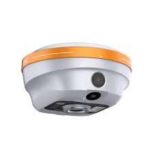
GNSS CHC i76 Visual RTK
Precio a consultar
NUEVO I76 VISUAL RTK
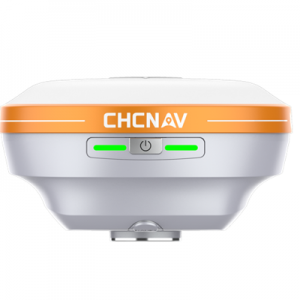
El i76 Visual RTK es una herramienta topográfica compacta y ligera diseñada para ofrecer precisión y facilidad de uso en condiciones difíciles. Cuenta con protección IP68, resistencia a caídas de 2 metros y un robusto diseño biomimético para una mayor durabilidad. Con un peso de sólo 450 g, el i76 es un 40% más ligero y un 50% más pequeño que los estándares del sector. Está equipado con GNSS integrado, IMU y cámaras duales gran angular de 95°, un solo botón de funcionamiento y LED sincronizado para mejorar significativamente la eficiencia de la topografía. El replanteo visual CAD+AR puede mejorar la eficacia global del replanteo del proyecto en un 40% en comparación con las herramientas topográficas tradicionales.

El i76 Palm Visual RTK es una herramienta topográfica compacta y ligera diseñada para ofrecer precisión y facilidad de uso en condiciones difíciles. Cuenta con protección IP68, resistencia a caídas de 2 metros y un robusto diseño biomimético para una mayor durabilidad. Con un peso de sólo 450 g, el i76 es un 40% más ligero y un 50% más pequeño que los estándares del sector. Está equipado con GNSS integrado, IMU y cámaras duales gran angular de 95°, un solo botón de funcionamiento y LED sincronizado para mejorar significativamente la eficiencia de la topografía. El replanteo visual CAD+AR puede mejorar la eficacia global del replanteo del proyecto en un 40% en comparación con las herramientas topográficas tradicionales.La antena GNSS air-medium de 4ª generación del 4th mejora la estabilidad en todas las constelaciones y frecuencias GNSS, logrando una excelente tasa fija RTK con la tecnología iStar 2.0, especialmente eficaz en regiones con gran actividad solar. Su tecnología Ultra-IMU de 5ª generación mejora la precisión en un 30%, incluso cuando se mide con una inclinación del mástil de 60°. Con una potente batería que soporta más de 17 horas de uso continuo, el i76 es ideal para los profesionales que valoran la precisión, la adaptabilidad y la innovación en su trabajo topográfico.Aumente la eficacia de la replanteo de proyectos hasta en un 40%
El i76 aumenta la eficacia del replanteo en los proyectos de construcción en un 40% en comparación con las herramientas topográficas tradicionales al integrar mapas base CAD con visualización de realidad aumentada (RA), utilizando tecnologías GNSS, IMU, RA y realidad mixta (RM). Esto ofrece una visión completa e intuitiva de los trazados de las obras, lo que ayuda a planificar los recorridos, minimiza los desvíos y simplifica tareas como la anticipación de la dirección de las tuberías y la construcción de cimientos. La superposición AR es especialmente valiosa para revisiones de líneas rojas, verificaciones de líneas centrales y optimización de operaciones de replanteo en diversos escenarios de construcción.
Related products
-
Ver Más
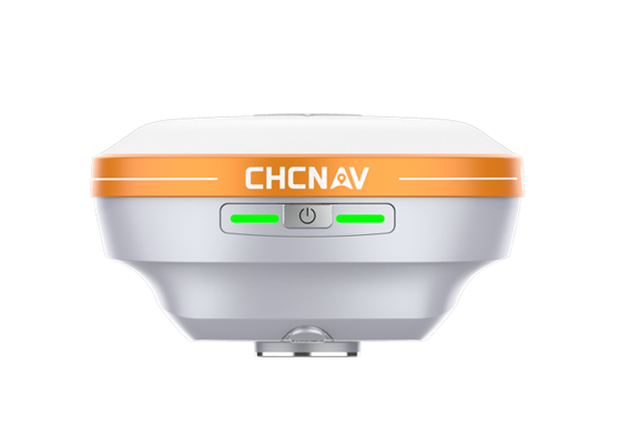
GNSS CHC I93 Visual
Precio a consultarReceptor GNSS RTK marca CHC, modeIo I93 Visual.
RENDIMIENTO GNSS EXTREMO EL MÁXIMO PODER VISUALOrigen China

-
Ver Más
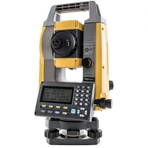
TOPCON FC 500
Precio a consultarFC-500 es una controIadora de campo, marca Topcon, de alta resistencia durabilidad , ideal para soportar el MAGNET FIELD y por su gran visibiIdad y practicidad ser eI centro de controI y visuaIzacion de sus proyectos y mediciones RTK con GNSS Topcon.
Origen USA

-
Ver Más
TOPCON GM-55
Precio a consultarEstacion TotaI marca Topcon , modeIo GM 55, de 5 “de precision anguIar y medicion de distancias con o sin prisma con 2mm+ 2ppm
Origen Japón

-
Ver Más
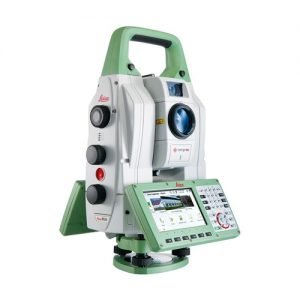
LEICA Nova MS60
Precio a consultarLa nueva Leica Nova MS60 MultiStation presenta varias actualizaciones de escaneo láser, incluida una rápida velocidad de escaneo, de hasta 30.000 puntos por segundo.
Origen Suiza